Palouse History
Geography and History
The origin of the name "Palouse" is unclear. One theory is that the name of the Palus tribe (spelled in early accounts variously Palus, Palloatpallah, Pelusha, et cetera) was converted by French-Canadian fur traders to the more familiar French word pelouse, meaning "land with short and thick grass" or "lawn." Over time, the spelling changed to Palouse. Another theory is that the name was in the first place a French word, describing the area which was then applied to the indigenous people inhabiting it.
Traditionally, the Palouse region was defined as the fertile hills and prairies north of the Snake River, which separated it from Walla Walla County, and north of the Clearwater River, which separated it from the Camas Prairie, extending north along the Washington and Idaho border, south of Spokane, centered on the Palouse River. This region underwent a settlement and wheat-growing boom during the 1880s, part of a larger process of growing wheat in southeast Washington, originally pioneered in the Walla Walla County south of the Snake River.
While this definition of the Palouse remains common today, sometimes the term is used to refer to the entire wheat-growing region, including the Walla Walla County, the Camas Prairie of Idaho, the Big Bend region of the central Columbia River Plateau, and other smaller agricultural districts such as Asotin County, Washington, and Umatilla County, Oregon. This larger definition is used by organizations such as the World Wide Fund for Nature, who define the Palouse Grasslands ecoregion broadly.
The community of Palouse, Washington, is located in Whitman County, about 7 miles (11 km) west of Potlach, Idaho.
Nevertheless, the traditional definition of the Palouse region is distinct from the older Walla Walla region south of the Snake River, where dryland farming of wheat was first proved viable in the region in the 1860s. During the 1870s, the Walla Walla region was rapidly converted to farmland, while the initial experiments in growing wheat began in the Palouse region, which previously had been the domain of cattle and sheep ranching. When those trials proved more than successful, a minor land rush quickly filled the Palouse region with farmers during the 1880s. The simultaneous proliferation of railroads only increased the rapid settlement of the Palouse. By 1890 nearly all the Palouse lands had been taken up and converted to wheat farming.
Unlike the Walla Walla Country, which was solidly anchored on the city of Walla Walla, the Palouse region saw the rise of at least four centers, all within several miles of each other: Colfax (the oldest), Palouse, Pullman, and on the Idaho side, Moscow. These four centers, along with at least ten lesser ones, resulted in a diffused urban pattern, relative to the centralized Walla Walla county.
Cities along the borders of the Palouse, in some definitions included within the Palouse region, include Lewiston, Idaho, serving the Camas Prairie farmlands, Ritzville, serving the eastern edge of the Big Bend Country, and Spokane, the major urban hub of the entire region. So dominant was Spokane's position, it became known as the capital of the Inland Empire, including all the wheat producing regions, the local mining districts, and lumber producing forests. Spokane also served as the main railroad and transportation hub of the entire region.
By 1910, although local terms like Palouse, Walla Walla Country, Big Bend, Umatilla Country, and Camas Prairie, continued to be common, many people of the region began to regard themselves as living in the Inland Empire, the Wheat Belt, the Columbia Basin, or simply Eastern Washington, Oregon, or North Idaho.

Geology
The peculiar and picturesque silt dunes which characterize the Palouse Prairie were formed during the ice ages (Alt and Hyndman 1989). Blown in from the glacial outwash plains to the west and south, the Palouse hills consist of more or less random humps and hollows. The steepest slopes, which may reach 50% slope, face the northeast. The highly productive loess ranges from 5 to 130 cm (2 to 51 in) deep.[8] Large areas of level land are rare.
Higher elevations bordering the prairies such as the Palouse Range support an often dense coniferous forest. Moscow Mountain is the tallest of the range, 4,983 feet (1,519 m) above sea level; it is located eight miles (13 km) northeast of the city of Moscow.

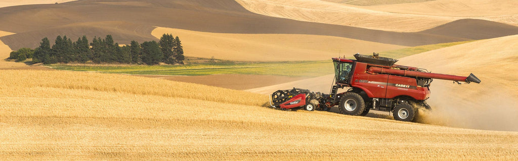
Farming
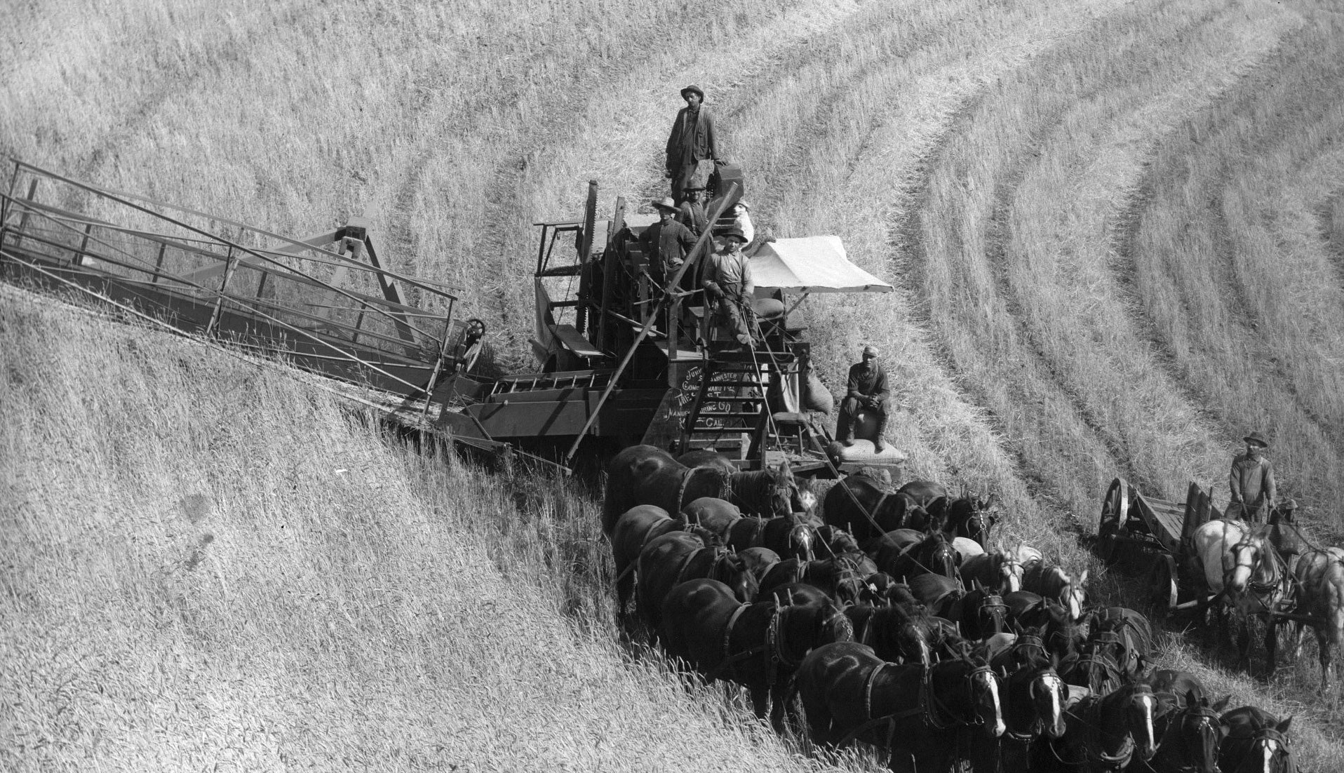
Early farming was extremely labor-intensive and relied heavily on human and horse-power. An organized harvesting/threshing team in the 1920s required 120 men and 320 mules and horses. Teams moved from farm to farm as the crops ripened. By this point, the combine had been invented and was in use, but few farmers had enough horses to pull such a machine, which required a crew of 40 horses and six men to operate on level ground. Because of this, use of combines on the Palouse lagged behind use in other farming communities in the United States.
It was only when the Idaho Harvester Company in Moscow began to manufacture a smaller machine that combine harvesting became feasible. By 1930, 90% of all Palouse wheat was harvested using combines.
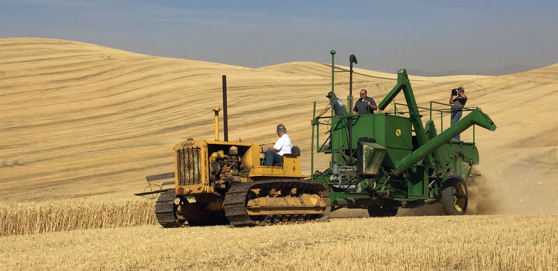
The next step in mechanization was development of the tractor. As with the combines, the first steam engine and gasoline-powered tractors were too heavy and awkward for use on the steep Palouse hills. The smaller, general use tractors introduced in the 1920s were only marginally used. As a result, by 1930, only 20% of Palouse farmers used tractors.
Today, the Palouse region is the most important lentil-growing region in the USA.
Palouse. (2015, April 30). In Wikipedia, The Free Encyclopedia. Retrieved 18:21, June 9, 2015, from http://en.wikipedia.org/w/index.php?title=Palouse&oldid=660007342